
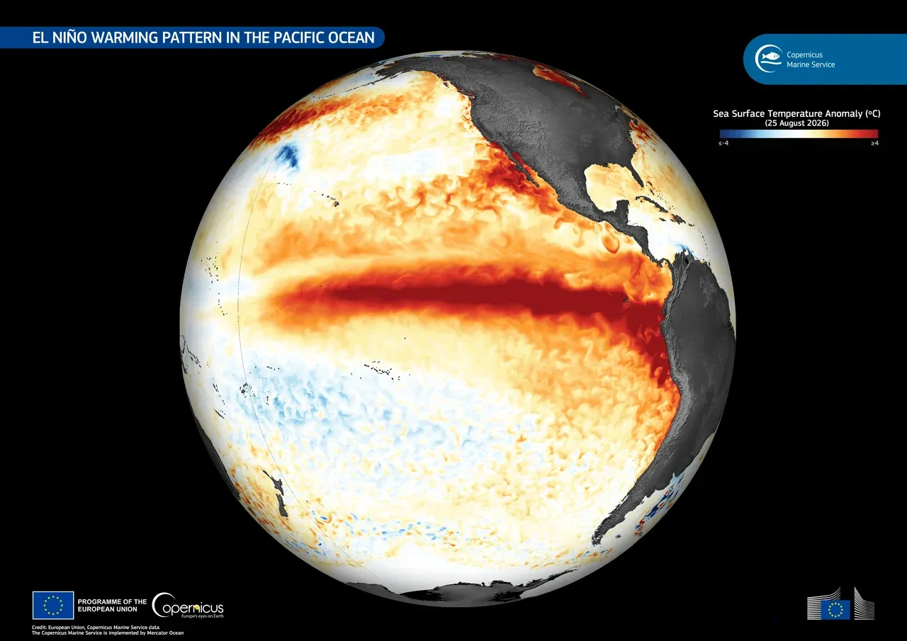
The warm water that has been piling up along the equatorial Pacific all year is now close to a record. NASA published satellite measurements on October 15, 2026 showing surface temperatures in the eastern Pacific running about 3°F (1.7°C) above their long-term average, with room to climb a fraction of a degree further in the coming months.
NOAA's Climate Prediction Center puts the probability at 83% that the October–December season will register as the strongest El Niño since 1950, the start of the modern record.
A pulse that began near Micronesia in January
Satellites first picked up the signature in January, when a Kelvin wave — a slow pulse of warm water traveling east along the equator, deep enough to be invisible from a ship's deck but not from orbit — formed near Micronesia. By early April the waves had reached the eastern Pacific and surface temperatures there had started to rise.
"Kelvin waves are like the heartbeat of El Niño," said Josh Willis, the project scientist for NASA's sea level missions at the Jet Propulsion Laboratory.
The ocean is physically higher
Warm water takes up more room than cold water, which is why an El Niño shows up as a bulge. Parts of the eastern Pacific are now sitting 1 to 1.3 feet (30 to 40 centimeters) above normal, and that high water is moving toward South America before turning north along the coast toward California. On the far side of the basin, around Indonesia and northern Australia, sea level is running 6 to 8 inches (15 to 20 centimeters) lower than usual.
The height measurements come from the Sentinel-6 satellites, which map the surface of the ocean roughly every 10 days. The continuous satellite record of sea surface height goes back to 1993, which is what allows this event to be ranked against the two extreme El Niños of 1997–98 and 2015–16.
A second instrument is watching a different consequence. NASA's PACE mission tracks the color of the ocean, and the equatorial Pacific has turned measurably bluer over recent months — the signature of phytoplankton dying back as the warm layer cuts off the cold, nutrient-rich water that normally rises from below. Less phytoplankton at the bottom of the food chain tends to push fish, and the fleets that follow them, into new ground.
What would make it historic
NOAA does not declare an El Niño's strength from a single week. It ranks events on three-month averages of the Relative Oceanic Niño Index, or RONI, a measure designed to separate the El Niño signal from the general warming of the tropical oceans.
The numbers so far:
- +1.7°C — the relative sea surface temperature anomaly in the central tropical Pacific in August, which rose to +2.1°C in September
- +1.7 — the RONI for the completed July–September season
- +2.4°C — the latest weekly Niño-3.4 anomaly reported by the Climate Prediction Center
- above +2.0 — what the August–October average has to clear for the event to be officially labeled "very strong"
- +2.5°C or higher — the three-month RONI that would beat every El Niño since 1950
The Climate Prediction Center's odds of clearing that last bar are 54% for September–November, 83% for October–December and 70% for November–January. The center considers it effectively certain that the event reaches "very strong" status.
A wetter South, a warmer North
NOAA turned those numbers into a forecast on October 15, when it released its outlook for the winter of 2026–27, covering December through February.
Warmer-than-average conditions are favored across much of the northern United States — the Pacific Northwest, the northern Rockies, the Midwest, the Mississippi Valley, much of the East, and Alaska, along with northern California, Puerto Rico and the US Virgin Islands. The Southeast, including Florida, is most likely to see near-normal temperatures.
On rainfall, the tilt runs the other way. Wetter-than-average conditions are favored from the Southwest across the southern tier and the Southeast, and north along the East Coast; in parts of the extreme Southeast and northern Florida the probability of above-normal precipitation exceeds 70%. Drier-than-average conditions are favored in parts of the northern Rockies and the Great Lakes, and across much of western and central interior Alaska.
The accompanying drought outlook, running from October 15 through January 2027, expects drought to ease or end across the Southwest, the southern Great Plains, the Southeast and parts of the East Coast, while developing or worsening in parts of the northern Rockies, northeastern Oregon and eastern Washington.
One caution is built into the format: a seasonal outlook shifts the odds, it does not schedule the weather. A 70% chance of a wetter-than-normal winter in northern Florida is a bet, not a forecast of any particular storm, and the two previous extreme El Niños both peaked in late November or early December — meaning the strongest effects of this one are still ahead of the measurements. The Climate Prediction Center updates the seasonal outlook on November 19.
Reporting from NASA, NOAA's Climate Prediction Center and NOAA Climate.gov.